The national parks and monuments of the United States have been called the world’s most magnificent rock collection for good reason. Of the National Park Service’s 189 national parks and monuments, most have geologic features that are described either as “significant” or “spectacular.”
Each year, these remarkable landforms attract hundreds of millions of visitors. For those interested in geology, the time to visit the national parks and monuments has never been better, thanks to updated and upgraded geologic explanations.
Historically, geology had long taken a backseat to the parks’ more obvious attractions of scenery and wildlife. But in the 1950s and 1960s, growing numbers of visitors began showing interest in the earth sciences, especially geology. In the early 1990s, the National Park Service began rethinking the role of geology as an attraction. Since then, it has placed greater emphasis on geologic education—in other words, on the science behind the scenery.
Awe-Inspiring Geology
Today’s visitors still marvel at the landforms for which the national parks and monuments are famous. But now, more detailed exhibits, improved interpretive signage and focused ranger programs and lectures make it easier for visitors to learn.
The landforms in the national parks and monuments were created by five basic geologic processes: sandstone erosion, volcanics, groundwater dissolution and redeposition, glaciation and mountain building and faulting.
The Colorado Plateau
The Colorado Plateau, an elevated physiographic region that covers 130,000 square miles in the Southwest’s greater Four Corners region of Arizona, Utah, New Mexico, and Colorado, has the best examples of sandstone-erosion landforms.
The Laramide Orogeny, the tectonically driven uplift that created the Rocky Mountains some 70 million years ago, raised much of the Southwest more than two vertical miles to form the Colorado Plateau. This uplifting accelerated the rate of wind and water erosion across this vast expanse of brightly colored sedimentary rock to eventually create an array of canyons, cliffs, arches, pinnacles, and pedestals.
Grand Canyon National Park
The Colorado Plateau has nine geologically oriented national parks and monuments—the greatest concentration in the nation. Among them and heading the list is northern Arizona’s Grand Canyon National Park. The walls of the 277-mile-long, 18-mile wide, 6,000-foot-deep Grand Canyon expose 40 major sedimentary strata from the four major eras in the Earth’s evolutionary sequence: Precambrian, Paleozoic, Mesozoic and Cenozoic.
Ranging in age from 200 million years to 1.9 billion years, these rocks represent the longest exposed span of geologic time on Earth. Yet the canyon itself, which formed after many rivers had consolidated into the Colorado River, is a mere six million years old.
Visitor centers on both the park’s north and south rims provide detailed explanations of the canyon’s origin and complex stratigraphy. Virtually every type of geologic feature within the canyon is visible from the South Rim’s Yavapai Geology Museum, which also marks the start of the 1.3-mile-long Trail of Time. This interpretive walking tour, designed so that each meter of travel represents one million years, helps visitors to grasp the magnitude of geologic time.
Petrified Forest National Park
Also in northern Arizona is Petrified Forest National Park, a barren landscape of mesas, gullies, and buttes that exposes thousands of 225-million-year-old petrified logs and the brightly colored Triassic Period strata of the aptly named Painted Desert.
Fascinating Formations
Near Moab, Utah, Arches National Park protects the world’s greatest concentration of natural arches—more than 2,000, including 306-foot-long Landscape Arch, the longest arch in North America; 112-foot-high Double Arch; and 45-foot-high Delicate Arch, one of the National Park Service’s iconic symbols.
Millions of years ago, winding watercourses in what is now the park had undercut deep “potholes” at the base of numerous cliffs. As erosion reduced the overall surface, these undercut cliffs were transformed into the park’s celebrated arches, a lengthy and complex process that is explained in educational exhibits. Arches National Park also has many red-and-yellow sandstone pinnacles, including Balanced Rock, a thin spire atop which is a precariously balanced 3,500-ton sandstone boulder.
In his book Desert Solitaire, author Ed Abbey described the vast mazes of canyons and buttes in nearby Canyonlands National Park as the “most weird, wonderful and magical place on Earth.” The Colorado and Green rivers divide this park into the Maze, Islands in the Sky, and Needles districts, each with unique, dramatic landforms that water has carved from 300-million-year-old sandstone.
Southern Utah’s Bryce Canyon National Park and Cedar Breaks National Monument feature thousands of brightly colored stone pinnacles, spires, pedestals, and thin columns called hoodoos. These features were created when sandstone formations developed vertical joints (fractures) during the stress of regional uplifting. Water then seeped into these joints and, in a process called “frost wedging,” froze, expanded, and separated them.
Tall, thin spires eventually formed wherever hard caprock protected the underlying rock from further erosion. The spires’ bright red, orange, yellow, and purple colors are due to the presence of iron and manganese oxides within the sandstone.
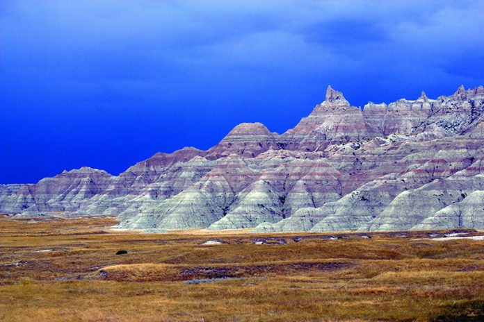
Although not on the Colorado Plateau, South Dakota’s Badlands National Park is another extraordinary example of sandstone erosion, a process that continues today. Sections of this expanse of deep gullies, sheer slopes, and sharp ridges lose a half-foot of surface material each year—one of the world’s highest erosion rates.
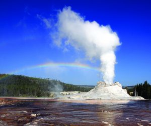
One of the many parks and monuments that showcase volcanic landforms is Wyoming’s Yellowstone National Park, the site of the Yellowstone Caldera, a collapsed volcano that is part of North America’s largest volcanic system. Sections of the park lie atop a 37-mile-long, 18-mile-wide magma chamber that in places is only 3 miles deep. Known as the Yellowstone Hot Spot, this plume of magma that has risen high into the Earth’s crust is the heat source for the park’s 10,000 geothermal features. These include erupting geysers, brilliantly colored hot springs, steaming fumaroles, and bubbling mud pots.
In recent geologic time, Yellowstone has hosted three catastrophic volcanic eruptions. The most recent, though not catastrophic, occurred just 77,000 years ago and was far larger than any eruption witnessed in historic times.
A 270-mile-long succession of calderas extending from Yellowstone west into Idaho and Oregon formed over a period of 17 million years as the North American tectonic plate drifted westward over the geologically stable Yellowstone Hot Spot. This succession of calderas was created at the rate of 15 miles per one million years—precisely matching the tectonic-drift rate of the North American Plate.
The maze of lava flows, cinder cones, vents, fissures, and tubes (caves) in southern Idaho’s Craters of the Moon National Monument and Preserve marks the position on the North American Plate that overlaid the Yellowstone Hot Spot 10 million years ago.
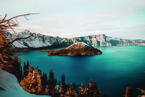
At Oregon’s Crater Lake National Park, the beautiful, 21-square-mile Crater Lake formed 7,700 years ago after the Mount Mazama volcanic system erupted, then subsequently collapsed. The resulting caldera later filled with rainwater and snowmelt to become 1,949-foot-deep Crater Lake, the nation’s deepest lake.
Six volcanoes in southern Alaska’s Katmai National Park and Preserve have erupted in historic time and seven others in recent geologic time. This park was established following the simultaneous 1912 eruptions of two volcanoes: Mount Katmai, which formed a crater lake, and Novarupta, which created the Valley of Ten Thousand Smokes with its countless, still-steaming fissures and fumaroles.
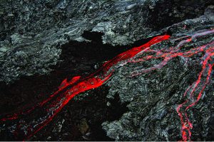
To observe the effects of very recent or even current volcanic activity, the place to go is Hawaii Volcanoes National Park on the island of Hawaii. Among the park’s volcanoes are 4,091-foot-high Kilauea, the world’s most active volcano, which last erupted in 2018, and 13,679-foot-high Mauna Loa, the world’s largest shield volcano.
Captivated by Caves
The 4,700 documented caves scattered throughout the national parks and monuments are classified into four types. Lava caves or tubes are conduits in lava flows; talus caves are open spaces beneath mountain talus slopes. Sea or littoral caves are carved by wave action, while large and often spectacular solution caves are created by the dissolution of limestone and dolomite bedrock.
Solution caves originate when groundwater dissolves the calcium carbonate in limestone and the calcium magnesium carbonate in dolomite rock to create subterranean tunnels, chambers, and galleries. Later redeposition of dissolved carbonate minerals created such decorative cave formations as drapery-like flowstones, icicle-shaped stalactites, spire-like stalagmites, columns connecting floors with ceilings, and twisted growths called helicitites.
Mammoth Cave in Kentucky’s Mammoth Cave National Park is the world’s largest limestone cave and contains more than 300 miles of explored passageways. Wind Cave in South Dakota’s Wind Cave National Park, the world’s eighth-largest limestone cave, is known for its glittering “boxwork” calcite crystals. At Carlsbad Caverns in New Mexico’s Carlsbad Caverns National Park, the world’s largest underground galleries are adorned with an unusual diversity of cave formations.
Glaciers and Glaciated Landscapes
Another geologic attraction in the parks and monuments are glaciers and glaciated landscapes. At Minnesota’s Voyageur National Park, the scouring of continental glaciers has uncovered 2.1-billion-year-old Precambrian rocks—North America’s oldest exposed rocks. The topography of Michigan’s Isle Royal National Park, an island in Lake Superior, consists of long parallel ridges, lakes, and bogs that Pleistocene continental glaciers carved from granite bedrock. At Acadia National Park, located largely on Maine’s Mount Desert Island, continental glaciers have left behind rounded granite hills that border a rockbound coast.
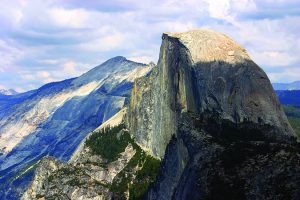
The effects of regional (alpine and valley) glaciation—deep valleys, rounded granite domes, and the sheer, half-mile-high rock faces of the imposing El Capitan and Half Dome monoliths—await visitors at California’s Yosemite National Park. El Capitan and Half Dome are textbook examples of roche moutonnée features. On their up glacier sides, these masses of bedrock are gently inclined and rounded. But on their down glacier sides, Pleistocene ice sheets have scoured away jointed granite. This has left sheer cliffs and such famed waterfalls as 2,425-foot-high Yosemite Falls and 1,612-foot-high Ribbon Falls.
At Washington’s North Cascades National Park, more than 300 valley, alpine, and cirque glaciers represent the largest concentration of active glaciers in the lower 48 states. The park’s ranges of high, jagged peaks are characterized by deep glacial troughs, glacially dissected uplands, and numerous roche moutonnée features.
Southern Alaska’s Glacier Bay National Park and Preserve is the site of more than 1,000 tidewater and terrestrial glaciers. There are broad ice fields, creviced glacial termini, calving glaciers and glaciated landscapes. Heavy rainfall and snowfall constantly replenish these glaciers, making this park an ideal field laboratory to study glacial advances and retreats.
Mountain Building
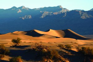
Mountain building and faulting created California’s Death Valley National Park’s dramatic, barren landscape of playas, sprawling alluvial fans, young volcanic craters, sand dunes and narrow canyons. The floor of Death Valley, elevation 282 feet below sea level, is North America’s lowest point—yet 11,000-foot-high summits within the park are only 12 miles distant.
With six major geologic faults, Death Valley is a rift valley that formed when long blocks of crust slowly subsided between parallel fault systems. Fault displacement of more than 10,000 vertical feet accounts for the park’s wildly varying elevations. Surface traces of faults and their associated steep escarpments are clearly visible at several points within the park.
At Wyoming’s Grand Teton National Park, extremely old rocks are exposed on some of the continent’s youngest mountains. Just 10 million years old, the Grand Tetons are much younger than the main chain of the Rocky Mountains. They continue to uplift along the active, 40-mile-long Teton Fault. This fault displaces about one foot every 300 years, meaning that the valley floor is still sinking while the Tetons continue to rise.
Many lesser-known parks and monuments also have fascinating geologic attractions. Among these are the following.
- The symmetrical volcanic cinder cone at New Mexico’s Capulin National Monument and the snow-white gypsum dunes at White Sands National Park.
- Rhyolite-tuff pillars at Arizona’s Chiricahua National Monument.
- The intricate maze of lava-tube caves at California’s Lava Beds National Monument.
- The recovering volcanic landscape left by the 1980 eruption of Mt. St. Helens at Washington’s Mt. St. Helens National Volcanic Monument.
- The 1,200-foot-high volcanic neck at Wyoming’s Devils Tower National Monument, the latter an iconic image in the 1977 movie “Close Encounters of the Third Kind.”
With a few dramatic exceptions of ongoing volcanism, glacial movement, and rapid erosion, along with the occasional collapse of spires and arches, the parks’ geologic features have changed relatively little since the first parks were established in the late 19th century. Since then, however, the understanding of geology and geologic processes has advanced considerably.
Showcasing Geology
For many decades, the National Park Service had adhered to outdated ideas in its presentations of park geology. It continued to emphasize scenery and wildlife while focusing attention on visitor services rather than visitor education. But by 1990, the National Park Service realized that its geologic presentations had fallen well behind scientific advancements.
In 1995, the National Park Service established its Geologic Resources Division, a branch charged with inventorying the parks’ geologic resources; improving visitor safety regarding geologic features; preparing geologic training manuals for park rangers who guide visitors; monitoring and measuring geologic changes within the parks, and monitoring mining and other activities in areas adjacent to the parks.
Today, the National Park Service’s Geologic Resources Division employs 30 geologists. One of their most important jobs is upgrading the parks’ educational exhibits, signage and presentations.
Along with the world’s most magnificent rock collection, the national parks have also been called the world’s greatest set of outdoor classrooms. Geology courses at numerous colleges and universities rely heavily on field trips. The national parks are a favorite destination.
But anyone can transform a visit to the national parks and monuments into an exciting and educational geology field trip. All that’s needed is to remember to take full advantage of the visitor centers and educational centers. They bring the parks’ geology to life through updated and improved ranger programs, exhibits, and interpretive displays.
An excellent primer to national park field trips is Geology of the National Parks (2020, Kendall/Hunt Publishing Company, Dubuque, Iowa) by David Foster, David Hacker, and Ann Harris. Both formats have hundreds of excellent photographs and maps, as well as a dedicated chapter for each of 59 geologically oriented national parks. While the 2020 edition is an excellent reference, it is not inexpensive; the hardbound 6th edition (2004) is more affordable and still widely available.
Now that geology has come of age in the National Park System, there’s no better time to enjoy the parks’ remarkable beauty, vistas, and landforms, and to learn about the science behind the scenery.
For information about the national parks and monuments, visit www.nps.gov.
This story about geology in the National Parks previously appeared in Rock & Gem magazine. Click here to subscribe! Story by Steve Voynick.


